

Kettle Valley Railway
- Coast Mountain Circle Tour
- Discovery Coast Circle Tour
- Fraser Country Circle Tour
- Gold Rush Trail
- Hot Springs and Heritage Circle Tour
- Kettle Valley Railway Tour
- Northern British Columbia Circle Tour
- Pacific Marine Circle Tour
- Peace River Country Circle Tour
- Sunshine Coast Tour
- Totem Circle Tour
- Valley Vineyards Circle Tour
- Okanagan Lakes & Rivers Circle Tour

Kettle Valley Railway Tour
The Kettle Valley Railway hangs on to the side of mountains and straddles deep valleys providing the traveller with amazing scenery and spectacular views.
Considered an engineering marvel, this historic railway, built in the early 1900s, has long been out of service, but it still draws visitors eager to explore the southern part of the Okanagan. Over the years parts of the railway bed have been converted to trails that are highly popular with both cyclists and hikers. Visitors can access these trails from the towns of Tulameen, Coalmont, Princeton, Summerland, Penticton, Naramata, Beaverdell, Rock Creek, Midway, Greenwood and Grand Forks.
This tour can be driven in one day but we suggest you take two-to-three days to enjoy the amazing countryside that winds 360 km (216 mi) through cool mountain forests, over rivers, along stunning valleys and into Canada’s only true desert.
Route Directions
- From Princeton, take Highway 3 east to Keremeos (67km / 40mi) and then wind down into Osoyoos (48km / 29mi).
- Continue on Highway 3 to Rock Creek (50km / 30mi), where you will head north on Highway 33 to Kelowna (130km / 78mi).
- Take Highway 97 south from Kelowna along the west side of Okanagan Lake to Peachland and then down to Summerland (51km / 30mi) and on into Penticton (14km / 8mi).
Tour Experiences & Itinerary
Princeton to Osoyoos
This drive starts in Princeton, a small town surrounded by spectacular lakes and provincial parks. Before setting out from Princeton however a side trip to Tulameen is well worth taking.
The drive to Tulameen north of the town takes you along a 26 km (16 mi) winding road that hugs mountainsides and curves around the Tulameen River, following part of the original Kettle Valley Railway. You will pass through the old mining community of Coalmont with its handful of historic buildings and then continue on to Tulameen and Otter Lake Provincial Park, an excellent stop for a picnic, swim and other recreational activities. This drive requires you return to Princeton on the same road.
You can explore the Kettle Valley Railway history in Princeton via the Trans Canada Trail, which runs through the region on the old KVR rail bed.
From Princeton, follow the Crowsnest Highway 3 for 38 km (23 mi) to Hedley, passing by the sagebrush banks of the Similkameen River and surrounding Cascade Mountains. At 21 km (13.4 mi) is the entrance to Bromley Rock Provincial Park, a popular picnic and swimming spot.
At Hedley, stop and stretch your legs in this quaint town. The Mascot Mine perched on Nickel Plate Mountain, an enduring landmark that chronicles the history of Hedley’s mining past and provides visitors a glimpse of the 80 year-old structures, is currently under reconstruction, but check back to see when it will reopen.

Back on Highway 3 keep your eyes open and binoculars ready as mountain goats roam the south-facing cliffs between Hedley and Keremeos. Entering Keremeos, 29 km (18 mi) from Hedley you will drive by an abundance of fruit stands all offering farm fresh produce that is locally grown. Keremeos is home to The Grist Mill & Gardens, one of the oldest working grist mills in North America. Visitors can walk among buildings dating back to 1900 set in beautiful heritage gardens.

Continue along the Crowsnest Highway 3 following the Similkameen River through the farming community of Cawston and south into Canada’s only true desert environment.

At the very southern end of the South Okanagan, just 48 km (29 mi) southeast of Keremeos, is the summer recreation destination of Osoyoos. Renowned for being situated in the middle of Canada’s only desert, it has the warmest freshwater lake in all of Canada, Osoyoos Lake. In and around Osoyoos, low rainfall and sandy soil create a desert environment that is home to over 30% of British Columbia’s threatened and endangered wildlife, rare insects, and plants. You can view this ecologically sensitive desert area at the Nk’Mip Desert Cultural Centre.
Osoyoos to Kelowna
Leaving Osoyoos on Highway 3 the terrain changes from desert to a temperate forest. At 17 km (10 mi) after climbing several switchbacks with stunning views stop at Anarchist Mountain Rest Area for a photo opportunity over the beautiful Okanagan Valley and Coastal Mountains.
The small community of Rock Creek resides 50 km (30 mi) from Osoyoos. Enjoy the glorious views as you drive back and forth along the ridge that descends into the town. Rock Creek was once a prosperous mining town and remains of its history can be found in the surrounding valleys and along the Kettle River.
From Rock Creek, at the junction of Highways 3 and 33, turn north onto Highway 33 to Kelowna following the original Kettle Valley Railway as it hugs the shores of the Kettle River and West Kettle River.
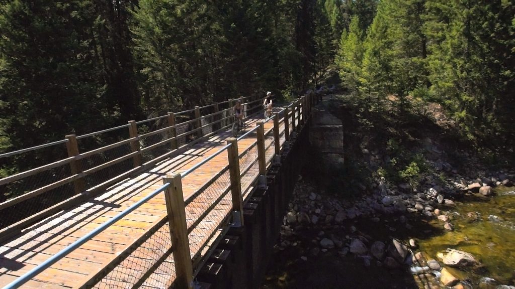
Watch for signs to Kettle River Provincial Park just a few kilometers up the highway. The Kettle Valley Railway runs through the park and forms part of the Trans Canada Biking Trail. You can walk parts of the historic Kettle Valley Railway here including a bridge across the river which is still intact.
Take in the beautiful scenery including the white cliffs that overlook the confluence of the West Kettle and Kettle Rivers at Westridge, as you drive the 130 km (78 mi) to the Junction of Highway 97 and Highway 33 in Kelowna.

Once in Kelowna, consider taking a side trip to Myra Canyon to explore some of the most scenic areas of the Kettle Valley Railway and popular with both hikers and cyclists. From the Junction of Hwy 33 and Highway 97 turn left and left again at Benvoulin Road next to Orchard Park Shopping Centre. Turn left at KLO Road which leads into McCulloch Road and then on to June Springs Road. Continue on to the parking lot at the end. Note: Some of this road is gravel. Distance from Hwy 97 is approximately 23 km (14 mi). Myra Canyon was designated a National Historic Site of Canada in 2002.
Return to Highway 97 in Kelowna which is the main arterial road through the city and turn left (south). Kelowna is the largest city in the region and has much to offer the visitor. It is blessed with spectacular mountain scenery, pristine lakes, sandy beaches, and fruit laden hillsides. You may want to stay a while to experience some of its wineries, golf courses, beaches and water sports, or to do some shopping, enjoy excellent local foods in some of the many restaurants, and experience the arts and cultural activities.
Kelowna to Penticton
From Kelowna head south on Highway 97, 51 km (30 mi), through Peachland to Summerland. Once you have left Westbank – West Kelowna, Highway 97 hugs Lake Okanagan offering stunning views across the lake and down the valley towards Penticton. Summerland has an important connection to the Kettle Valley Railway linking this area to one of North America’s largest trestle bridges. At 73 m (235 ft) high and almost 200 m (650 ft) long, the McCulloch trestle is a good example of the challenges that this regional railway had to overcome.

In Summerland, you can take a ride on the Kettle Valley Steam Railway and experience what the journey was like 100 years ago. A 1924 Shay steam engine pulls 1950s passenger cars through the hillsides overlooking beautiful Okanagan orchards and vineyards. The 16 km (9.5 mi) of remaining track takes 2 hours to cover. Take the Rosedale exit from the highway in Summerland and follow the ‘KVR’ signs. The station is located 6 km (3.5 mi) from Highway 97.
The Bottleneck Drive wineries are located in Summerland and popular with visitors. Some of the areas best beaches are also found here. Peach Orchard Beach has a water park and boating facilities, while Okanagan Provincial Park and Sun Oka Beach Provincial Park are home to a mile of white sandy shoreline.
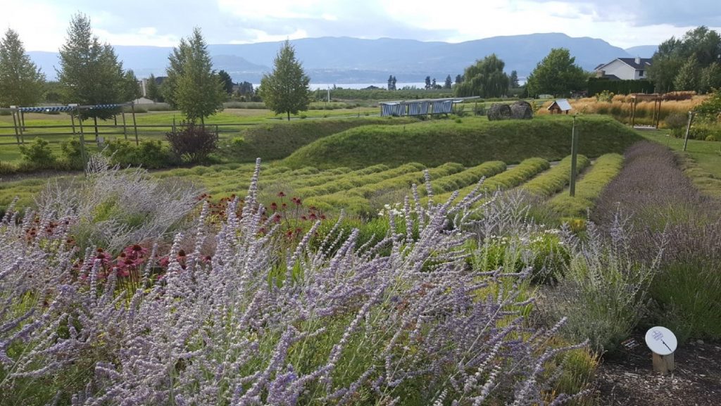
Continue south on Highway 97. Just outside Summerland near Sun Oka Beach is a right turn off to the Agricultural Canada Research Station which includes Summerland Ornamental Gardens. Once inside the park you can see one of the most spectacular features of the entire Kettle Valley Railway, the Trout Creek Bridge, the highest bridge along the railway at an amazing 73 m (235 ft) above the ground with a span of 188 m (617 ft). The unique xeriscape gardens located here never fail to fascinate visitors.
Returning to Highway 97, continue south into Penticton 9 km (5.4 mi) from the Agricultural Research Centre.

Penticton is well known for its wineries, beaches and the variety of outdoor activities. A drive along the Naramata Bench just east of Penticton offers some stunning views across Okanagan Lake and the slopes of the valley vineyards. Stop and taste some of the award winning wines and buy a few bottles to take with you. The Kettle Valley Railway hugs the shores of Lake Okanagan as it winds its way up past Naramata. This part of the railway has been converted into a trail that is very popular with recreationists.
BC Lodging & Campgrounds Association
209 - 3003 St John's Street
Port Moody, BC
Canada V3H 2C4