Northern BC
- Coast Mountain Circle Tour
- Discovery Coast Circle Tour
- Fraser Country Circle Tour
- Gold Rush Trail
- Hot Springs and Heritage Circle Tour
- Kettle Valley Railway Tour
- Northern British Columbia Circle Tour
- Pacific Marine Circle Tour
- Peace River Country Circle Tour
- Sunshine Coast Tour
- Totem Circle Tour
- Valley Vineyards Circle Tour
- Okanagan Lakes & Rivers Circle Tour

Northern British Columbia Circle Tour
This spectacular road odyssey of Northern British Columbia takes you through untamed wilderness and stunning mountain ranges unique to the immense region. Plan for eight to fourteen days of adventure, as you drive on the Yellowhead Highway 16, to the Northern British Columbia east-west corridor, north on the Stewart Cassiar Highway 37 (which cuts through the scenically stunning Coast Mountains), and finally south on the legendary Alaska Highway 97, which contains historic towns surrounded by dramatic landscape. The 1,800 kilometres (1,080 miles) trip is full of wildlife, mountain scenery, and heritage sites.
Route Directions
- From Prince George, travel west along Yellowhead Highway 16. Vanderhoof is the first community (97 km / 58 mi), and then Smithers (175 kilometres / 105 miles).
- Head north on the Stewart-Cassiar Highway 37 to Meziadin Junction (161 km / 97 mi) and take a side trip to Stewart and Hyder Alaska (62km / 37mi). Back on the Stewart-Cassiar Highway 37, Dease Lake (329km / 197mi) is the last community before the Alaska Highway 97 and Yukon Border (234km / 140mi).
- A side trip to Atlin is 370 kilometres (222 miles) west along the Alaska Highway 97, and 97 kilometres (58 miles) south.
- Return to the Alaska Highway 97 and from Watson’s Lake, drive south into the northern Rockies to Fort Nelson (525 km / 315 mi).
- Continue south to Fort St John (387 km / 232 mi), the beginning of Peace River Country, and Dawson Creek (73 km / 44mi), Mile 0 of the Alaska Highway 97. Prince George (406km / 244mi) is the tour’s southern destination.

Tour Experiences
Prince George to Smithers
Start the tour in Prince George, aptly called the “Capital of Northern British Columbia”. This vibrant city, where outdoor recreation is year-round, is also home to over 120 parks. Exploration Place offers a chance to explore the cultural, scientific, and natural history of the region while the Prince George Native Art Gallery displays works from prominent Aboriginal artists. Finally, learn about the north’s industrial history at the Railway and Forestry Museum before heading west along Yellowhead Highway 16. Vanderhoof, 97km (58mi) from Prince George, marks the geographical centre of British Columbia and the start of the lakes district. Make sure to visit the Heritage Village Museum. For another fascinating glimpse into the past, take a detour north to Fort St. James National Historic Site – a fur trading post established by explorer Simon Fraser in 1806. Today, the fort guards the largest grouping of wooden buildings representing the fur trade in Canada. Then continue west through pristine wetlands and glistening lakes.

Houston is a forestry town located at the confluence of the Morice and Bulkley Rivers approximately 310 kilometres (190 miles) from Prince George. These are famed fly-fishing grounds for anyone in search of rainbow, steelhead, cutthroat, and Dolly Varden. Rightfully so, Houston is known as the “Steelhead Capital of Canada”.
As you continue west, mountains begin to encroach on the pastoral Bulkley Valley. The city of Smithers, a 66 kilometre (41 miles) drive from Houston, has adopted an alpine theme that suits its location under the snowy peaks of Hudson Bay Mountain. Red cobblestone walks and Bavarian storefronts have made the year-round recreation destination into a charming mountain city. While driving west, be sure to visit Twin Falls, a thunderous cascade of water fed by the melting glaciers of Hudson Bay Mountain. Also, stop alongside the highway to view of Moricetown Canyon and its raging rapids. For a more “Jurassic” adventure, explore Driftwood Canyon Provincial Park, which features fossil beds dating back 50 million years.

Roughly 62km (41mi) further up the Yellowhead Highway 16, the three Hazeltons (Old, South, and New) are home to the ‘Ksan Historic Village and Museum. Renowned for its replica Gitksan village, native guides provide tours and interpretations of traditional longhouses, dugout canoes, and totem poles. Northwest coast Aboriginal culture has been preserved here for over 7,000 years, and these towns offer an unparalleled opportunity to experience the surrounding region’s rich culture.
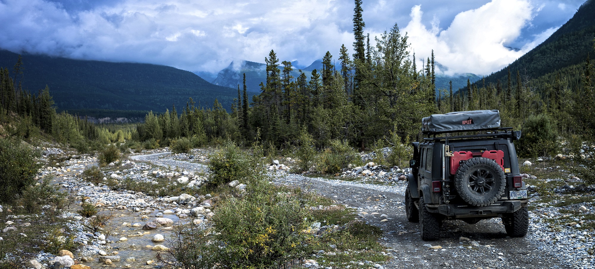
Kitwanga marks the turning point to head north from the Yellowhead Highway 16 on Highway 37, the Stewart-Cassiar Highway. This road travels 721 kilometres (433 miles) through scenic and remote landscape to the Yukon border. Wildlife is abundant and the few people along this route are friendly and casual. However, travellers are advised to drive with caution. The Stewart-Cassiar Highway 37 turns to gravel in places, many bridges are single-lane only and grades can be steep and winding. Reports like these only seem to increase the highway’s popularity with visitors and at the same time reinforce Northern British Columbia’s frontier mystique.

Side Trip to Stewart
The small service community of Meziadin Junction marks the turn-off to Stewart and Hyder, Alaska. If not for the historic communities at the end of the road, be sure to take this drive for a close-up look at the mountains and amazing ice flows along the side of the highway.

Traveling 232km (144mi) north of Meziadin Junction on the Stewart-Cassiar Highway 37 you will reach the small Aboriginal village of Iskut. Quietly nestled between Mt. Edziza Park and Spatsizi Wilderness Plateau, this quaint town is the primary base for excursions into Mount Edziza and Spatsizi Plateau Parks, with local guide services providing the experience required to venture into these wilderness areas. Dease Lake, located 491 kilometres (305 miles) north of Kitwanga , is the largest settlement on the Stewart-Cassiar Highway 37. It primarily serves as another centre for adventurers into the nearby parks. Locals will steer you in the right direction for guided trips, including flying over the incredible Grand Canyon of the Stikine.
Spatsizi Plateau Wilderness Park is one of Canada’s largest and most significant parks. It’s a pristine habitat for innumerable animals indigenous to northern environments. Caribou, moose, mountain goats, stone sheep, and giant hawk moths are just some of the wildlife inhabiting the park. Mt. Edziza is unique in its own sense with 230,000 hectares of protected volcanic landscape; it’s one of the few areas in all of British Columbia that showcases lava flows. These remote parks are not accessible by road and offer no on-site provisions or personnel, so come prepared with all necessary supplies.
From here the rough mountain road to Telegraph Creek winds along the beautiful Stikine River. An 80 kilometres (50 miles) stretch of impassable waters charging through 300 metres (1,000 feet) deep canyons have earned it the title “Grand Canyon of the Stikine”. Viewpoints on the road provide mesmerizing views of Mt. Edziza and its eerie volcanic landscape. This road, however, is a challenging drive and motorhomes and vehicles with trailers are discouraged from attempting it.
Heading north will bring you to Boya Lake Provincial Park, a great place for travellers to stop and rest. The lake is clear and clean; great for swimming; and set amongst glacially carved hills, depressions, and natural amphitheatres. This warm lake is filled with small tree covered islets perfect for lakeshore camping.
Side Trip to Atlin
The Stewart Cassiar Highway 37 eventually meets with the Alaska Highway 97 just inside the Yukon Territories. The tour continues east, but the community of Atlin makes a charming and unique side trip. To visit, travel west through the stunted forests, muskeg, and permafrost. At Jake’s Corner, follow gravel Highway 7 south back into British Columbia and to the serene, isolated community. Often considered a destination for those seeking spiritual enlightenment or creative inspiration, brightly colored Atlin is home to a small art community that attracts photographers, writers, painters, and naturalists. Guides offer hiking trips through Atlin Park, flight-seeing excursions over the ice fields and boat charters to Atlin Lake’s most tranquil coves.

When leaving Atlin and returning to the Circle Tour, follow the Alaska Highway 97 east through Watson Lake and back into the mountains of British Columbia. Remember to visit the sign-post forest at Watson Lake. A homesick highway worker put down the first signpost in 1942, and now there are over 50,000 and growing. From the Yukon Border, the Alaska Highway 97 winds 1,000 kilometres (600 miles) south to Dawson Creek through rugged mountain passes, flowered alpine meadows, ranch land, and prairies. This leg of the journey is known as the “Serengeti of the North” – try to spot wild stone sheep, American bison, deer, moose, bears, elk, and other wildlife from the roadsides.
Make sure you stop at Liard River Hotsprings Provincial Park at Mile 496 on Alaska Highway 97, where the lush wilderness is home to moose, bears, and exotic species of carnivorous plants. Over 250 different species of plants, including 14 different varieties of orchids, thrive in the heat, and humidity of this winter-land oasis. The two mineral rich pools, the hottest of which reaches 49 degrees Celsius, are among the most popular camping spots to relax and soak along the Alaska Highway 97. Reward yourself after a long day’s drive with a gentle soak in the soothing springs that have been used for centuries.
The 90 kilometres (55 miles) drive through Muncho Lake Provincial Park is said to contain the most spectacular scenery along the Alaska Highway 97. The word Muncho means Big Lake in the local native tongue – it refers to the 12 km (7.5 mi) jade green lake, which draws flocks of birds from their northern migration routes. The highway hugs the eastern shore, which hosts waterfront campsites, private lodges, and RV parks. Summer visitors book early in order to enjoy boat tours, fishing trips, and whitewater rafting excursions on this lake.
Fort Nelson to Fort St John
The next segment of the Alaska Highway 97 contains not only exceptional wildlife viewing – deer, moose, and black bear – but also the welcoming town of Fort Nelson, the oldest non-native settlement in British Columbia. Located 525 kilometres (315 miles) from Watson Lake, this town of 4,700 is a centre for agriculture, industry, and more recently, tourism. The city is a friendly community of rodeo fans and outdoor enthusiasts. When you arrive, make sure to check out the “Welcome Visitor Program”, a nightly introduction to Fort Nelson and its people. Talks and presentations by local ambassadors, personalities, and members of the Royal Canadian Mounted Police help visitors find their way and enjoy their stay.
From Fort Nelson, continue south until Mile 143 of the Alaska Highway 97 and take a break at Pink Mountain, home to a large population of fireweed blossoms, which give the mountain its name. This is a good place to stop and enjoy one of the many homespun restaurants before heading south on the Alaska Highway 97 into the Peace River district.
The Peace River district encompasses the communities of Fort St. John, Dawson Creek, and Hudson’s Hope. Fort St. John is a vibrant city that has experienced considerable growth in recent years. Deemed the “Energetic City” due to its developing oil and gas industry, Fort St. John is a commercial, shopping, and transportation hub in the Peace River area. In fact, this modern city is the largest metropolis along the Alaska Highway 97 with a population of over 17,000. While in the area, remember to spend some time at Charlie Lake. This 13 kilometre (8 miles) lake is the site of two provincial parks ideal for hiking, boating, fishing (for walleye and northern pike), and cycling.

Fort St John to Prince George
Heading south from Fort St. John, you can either take Alaska Highway 97 through Dawson Creek or Highway 29 through Hudson’s Hope before reaching Chetwynd. The road through Hudson’s Hope runs parallel to the spectacular Peace River for more than 70 kilometres (43 miles). Pull out the camera and capture the picturesque setting of tranquil flowing water banked by lush vegetation and wildlife. The city of Hudson’s Hope has a hint of an English village about it with winding roads, but is famous for its archeological importance. Named “The Land of Dinosaurs and Dams”, Hudson’s Hope has one of the highest concentrations of dinosaur fossils and footprints in North America and is also home to the W.A.C Bennett Dam. Keep an eye out for bear, deer, and elk in the area.
If you choose to head south on the Alaska Highway 97 to Dawson Creek, be prepared to enter a town full of history. Dawson Creek’s population exploded in 1942 when US troops led Canadian and American civilians in the rush to construct a 2,400 kilometres (1,491 miles) military supply route to Alaska. Pushing the trail through was accomplished in an amazing eight months and 21 days. After the war, the wilderness highway captured the imagination of urban pioneers everywhere and the great Alaska Highway 97 legend gathered momentum. The Mile 0 Post in the middle of town is one of the most photographed landmarks in the region. Leaving Dawson Creek, it’s a short but scenic drive to Chetwynd, a small town nestled in the foothills of the Rockies. Once known as Little Prairie, Chetwynd captures the hearts of visitors with its magnificent valleys, parkling lakes, serene rivers, and snow-capped mountains.
The final 140 kilometres (83 miles) portion of the journey from Chetwynd to Prince George is a beautiful and scenic drive. Along the way, make a stop at Pine Pass and the spectacular Bijoux Falls. In the area, Powder King Mountain Resort offers skiers and boarders an exhilarating chance to carve through fresh powder on 18 groomed runs. At last, you’re back in the bustling city of Prince George where you can reacquaint yourself with the modern amenities of a contemporary metropolis.
BC Lodging & Campgrounds Association
209 - 3003 St John's Street
Port Moody, BC
Canada V3H 2C4